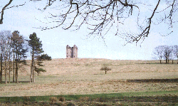
Lyme Park
 Lyme Park covers a huge area so a walk across it can amount to a mile or two just between the park boundaries. The park and the house are owned by the National Trust but managed by Stockport Metropolitan Borough Council. Information from Stockport Tourist Information Centre 0161-474 4444 or Lyme Park information centre 01663-766492. Although this walk is shown as of moderate difficulty it is actually entirely on made up drives and paths. The difficulty comes in the steepness and length of the hills. Starting at about 510 feet the walk rises to well over 700 feet in a mile with a deep ravine, below 500 feet, along the way; hard work on a hot day and no refreshment along the way other than sometimes at the start, at Lyme Hall when open and what you carry. Lyme Park covers a huge area so a walk across it can amount to a mile or two just between the park boundaries. The park and the house are owned by the National Trust but managed by Stockport Metropolitan Borough Council. Information from Stockport Tourist Information Centre 0161-474 4444 or Lyme Park information centre 01663-766492. Although this walk is shown as of moderate difficulty it is actually entirely on made up drives and paths. The difficulty comes in the steepness and length of the hills. Starting at about 510 feet the walk rises to well over 700 feet in a mile with a deep ravine, below 500 feet, along the way; hard work on a hot day and no refreshment along the way other than sometimes at the start, at Lyme Hall when open and what you carry.
Map: 1:25,000 series SJ98; 1:50,000 Landranger 109
Public transport: Buses running between Stockport and Macclesfield pass Nelson Road, Higher Poynton, 2 hourly on most days, stopping outside the Boar's Head. It is also possible to get a train along the Buxton line from Stockport and Hazel Grove, and alight at Middlewood halt. Climb to the high level bridge and walk south approximately half a mile to the old Higher Poynton station. Nelson Pit is adjacent to the bridge.
Start/finish point
Higher Poynton
Park in the Nelson Pit car park (SJ39443833) which is well signed along local roads. Make a point of looking at the visitor centre which will give you a taste for the history of this area - coal mining, the canal and tramways - it is hard to believe how industrialised this area was until only a few decades ago. Much more information on this interesting area can be found in Dave Kitching's pages.
Route
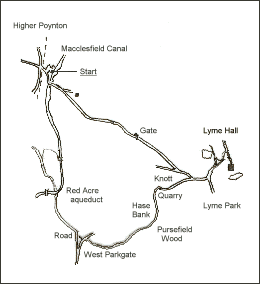
 The Macclesfield Canal runs alongside the top of the car park. Find your way onto the towing path and turn right. You will be able to obtain refreshment at the Trading Post on most days. Over the foot bridge past the bench (look forward to sitting on that when you get back!) and leave the towing path by the gate. Turn left up the drive and over the bridge, bridge 15 on the canal. The Macclesfield Canal runs alongside the top of the car park. Find your way onto the towing path and turn right. You will be able to obtain refreshment at the Trading Post on most days. Over the foot bridge past the bench (look forward to sitting on that when you get back!) and leave the towing path by the gate. Turn left up the drive and over the bridge, bridge 15 on the canal.
After the cattle grid, take the drive to the right. Follow this until you reach Lyme Hall. The white house about 200 yards up the hill is interesting - the right side is new but the tall vertical left side was built as a pit winding house for the shaft that was once in front of the building. Once into the park look out for [Sky] Larks which nest on the ground in spring along the side of the hill known as the Knott.
On reaching the Hall you may like to view the house and/or the gardens. The gardens were used for the making of the TV drama Pride and Prejudice where the hall played the part of Pemberley. Refreshment and toilet facilities are available. Have a look at the mill pond and the restored mill.
For the return you can retrace your steps, that is the shortest way (total just over 2 miles), or make a loop of the walk by taking the West Parkgate route (about 3 miles in total). Begin the latter by following the route you came in by. There are three junctions in the drive up here. Go right at the first but left at the second (you came in from the right). Follow this drive around the quarry, to the east of Hase Bank and down the delightful Pursefield Wood. This is always lovely but in May and June the rhododendrons make this one of the most beautiful of walks. The drive winds its way gently down hill for more than half a mile, together with the babbling stream.
Once you reach the park gate turn left, cross the stream bridge and then follow the footpath across the small field. This brings you to the road. Follow this road for just a few hundred yards through Red Acre Wood. Pass under Red Acre aqueduct and climb the steps to the towing path. Turn left and follow the towing path back to bridge 15 from whence you started. You'll be ready for that seat! Refreshments available at the Trading Post. |