Higher Poynton to Bollington

The short arm at Higher Poynton now occupied
by Braidbar
Boats and
Constellation Cruises was built by Lord Vernon in order to load
boats with coal from the Nelson Pit which was located where the
car park and visitor centre are now. In more recent times the
boating business was developed by the late Mrs. Edith Burgess.
Many are the tales of poor unsuspecting walkers and boaters who
infringed the dear lady's ‘rules’ and caught a real
tongue lashing! To those of us who knew her better she was a
kindly soul who really had the best interests of the canal at
heart. Edith Burgess lived for many years on the narrowboat Edward moored
immediately outside the arm and a seat has been placed nearby
in her memory. and
Constellation Cruises was built by Lord Vernon in order to load
boats with coal from the Nelson Pit which was located where the
car park and visitor centre are now. In more recent times the
boating business was developed by the late Mrs. Edith Burgess.
Many are the tales of poor unsuspecting walkers and boaters who
infringed the dear lady's ‘rules’ and caught a real
tongue lashing! To those of us who knew her better she was a
kindly soul who really had the best interests of the canal at
heart. Edith Burgess lived for many years on the narrowboat Edward moored
immediately outside the arm and a seat has been placed nearby
in her memory.
On either side of the canal between bridges 13 and 18 there is extensive evidence and remains of the once thriving Poynton coal mining industry.
Evidence of subsidence abounds - the playing field beside Brownhills Bridge, no. 15, is thought to have been almost level with the canal when the latter was built. Now there is a 4 metre drop! There is excellent mooring along here.
Other mining industry reminders abound, particularly the many
straight roads and tracks that used to be plateways or tramways
from the pits to the canal and, later, to the railway. It is also
possible to find buildings that once were pit heads of steam engine
houses.
Hagg Farm lattice footbridge, no. 16, supplemented the swivel
bridge at the same location and is thought to have been installed
during the 100 years of railway ownership (1847-1947) - notice
its similarity to railway pedestrian bridges. The swivel bridge
fell into disrepair, and had subsided to water level, and was dismantled
in the late 1970s.
Between bridge 16 and the narrows of a long gone swivel bridge,
notice on the towing path side the remains of bridge that once
took the towing path over a short arm. There have been proposals
in recent times to re-open this arm but nothing has come of them.
Just before Red Acre Aqueduct one of the many feeders enters the canal. Alas, this one no longer provides water due to the subsidence of the intake channel. The aqueduct is a typical example of the stout and very high quality stonework evident throughout the canal.
Shortly we pass Lyme View Marina, a huge area devoted to boat
moorings, giving a very good idea of just how popular this canal
is with boaters. Down the road and round the corner was the Miner's
Arms, now closed (2014) for re-development.
Past Braddock’s Bridge, no. 19, and over Adlington embankment,
one of the largest - notice the pierced stone fence posts. These
once carried redundant mine cables as the means to provide a fence.
I observed the last rusting remains in the late 1970s. We reach
Ryles Wood wharf, Styperson, by Ryles Bridge, no. 20. Wetton’s
despatched huge quantities of stone from Styperson quarry through
this wharf. See Gilbert Beeley's memories
of Styperson.
Along the very pastoral length between Ryles Bridge, no. 20, and Bollington we pass the North Cheshire Cruising Club wharf by Whiteley Green Bridge, no. 25. Mooring on the towing path side is reasonable here and a good place for the night if you want to stay out in the country. The Windmill inn is also close by, only 200m down the hill.
On a parapet stone on Whiteley Green Bridge is an engraved memorial to a 19thC. tragedy. It says Lovers Leap, June 1894.
At many points you will notice the fine stone milestones. There is one just a few metres south of Whiteley Green Bridge. They were restored in the early 1980's by a group of friends who went on to found The Macclesfield Canal Society in 1984. The milestones were buried at the beginning of the second world war for security reasons - and then forgotten. The society has thrived ever since and you may notice many of their improvement projects as you travel along the canal.
As we approach Sugar Lane Bridge, no. 26, we get our first view
of Kerridge Hill which will dominate the scene for a couple of
miles. Sugar Lane Bridge is perhaps the best example of the splendid
architectural stonework on the canal. This bridge is very skewed,
demonstrating exactly how the stonework should be angled to get
the right finish with maximum strength. For an illustrated description
of just how bridge 26 was built have a look at Bollington
Live! magazine, edition 19, page 13. These bridges were built
for the horse and cart. Today they take 38 tonne trucks without
the slightest protest. What a monument to the skill of their builders!
A hundred metres south of Sugar Lane Bridge look out for the wharf on the east side. Across the field, by the oak tree in the hedge, there is the entrance to a clay pit. The drift shaft leads deep under the hill. The clay, a particularly high quality fireclay, was hauled out and loaded onto boats for transport to a brickyard at Dukinfield, at the bottom of the Peak Forest Canal. The round trip was a single day's work for the boatman - 31 miles and twice through the sixteen locks at Marple!
Next page - Bollington.
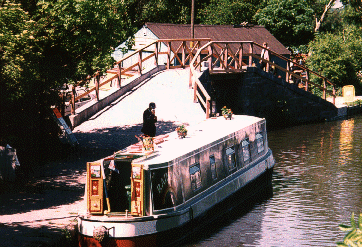
Higher Poynton - at bridge 15 on the Macclesfield canal, this was the centre of the coal mining activity along the canal. The canal under the towing path bridge is the Nelson Arm serving the Nelson pit which was located in the trees at the back of the picture. The foot bridge was raised by a foot (30cm) in 1997 because subsidence had reduced the headroom to such an extent that boats could no longer get into the arm if the canal was full! The pattern of railings was copied from a 1920's photograph.

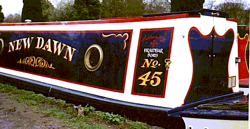
Nelson Arm is the base for Braidbar
Boats who are well known for
the quality of their work and in particular for their outstanding
boat painting. One of their boats is fully reviewed in Waterways
World,
December 2010. who are well known for
the quality of their work and in particular for their outstanding
boat painting. One of their boats is fully reviewed in Waterways
World,
December 2010. |