Bollington
 |
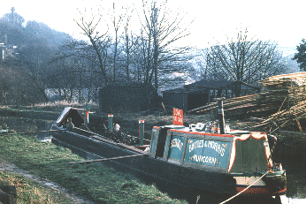
On the Macclesfield canal between Bollington aqueduct and bridge 27. The boat Hebble under the business name of Birtles & Morris, Runcorn, was pictured in 1977 delivering coal to local houses. The boatman was actually a young lady.
The timber yard is on Beard's Wharf (see wharves
pages) and closed in 1998. New houses are being built
here (2017).
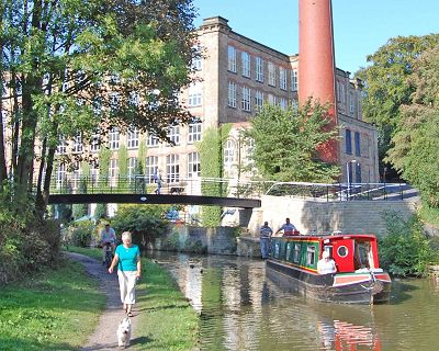
Bridge 26A footbridge has been built
by
Clarence mill off the picture to the left. |
The first sight of Bollington is
of Clarence
Mill . This enormous stone building (the largest mill
in Bollington) dates from 1831 and has been extended several times
since. It was built, like the other big mills in Bollington, to spin
cotton. The raw cotton was brought from Liverpool docks up the River
Irwell to Manchester then via the Rochdale, Ashton, Peak Forest and
Macclesfield canals. The cotton thread was then sent to other mills
in Lancashire to be woven into finished cloth. Waterhouse
Mill (now demolished) was said to spin the
finest (thinnest) cotton in the world and it was sought after by
lace makers everywhere including Nottingham and Brussels. . This enormous stone building (the largest mill
in Bollington) dates from 1831 and has been extended several times
since. It was built, like the other big mills in Bollington, to spin
cotton. The raw cotton was brought from Liverpool docks up the River
Irwell to Manchester then via the Rochdale, Ashton, Peak Forest and
Macclesfield canals. The cotton thread was then sent to other mills
in Lancashire to be woven into finished cloth. Waterhouse
Mill (now demolished) was said to spin the
finest (thinnest) cotton in the world and it was sought after by
lace makers everywhere including Nottingham and Brussels.
 Clarence
mill today houses Bollington's Discovery
Centre, right on the water side, almost next door to the Café Waterside, and the fascinating oriental carpet and decorative
nomadic items store,
The Weave,
is round the side of the mill, accessible directly from footbridge
26A and up the road beside the mill. Clarence
mill today houses Bollington's Discovery
Centre, right on the water side, almost next door to the Café Waterside, and the fascinating oriental carpet and decorative
nomadic items store,
The Weave,
is round the side of the mill, accessible directly from footbridge
26A and up the road beside the mill.
There is good mooring to rings on Lord Vernon's Wharf on the embankment
at Bollington. Coal once was unloaded here and thrown down the embankment
which provided staithes (remains still visible under the trees) where
the coal was stored before being loaded into carts and barrows for
local delivery. Walk to the aqueduct and look down on the old part
of the town; look up at Kerridge Hill to the building known as White
Nancy. This is thought to have been built to commemorate the
Battle of Waterloo (1815), but the origin of the name is a mystery;
there are many stories but not a shred of evidence for any of them!
White Nancy is ¾ mile uphill from br.27 (take the footpath
on left just past Poplar Drive, straight through Gleave Avenue, down
the footpath, left at Chancery Lane, keep right, take the footpath
into the field at the start of Cow Lane), follow your nose.
Aqueduct Cottage was, until it lost its licence in about 1905,
the Navigation ale house, and the canal horses resided in stables
beneath. Walk carefully down the Hole i' th' Wall Steps beside the
aqueduct to visit the many shops and pubs.
Look at the river Dean which runs in a tunnel deep under the canal
- see it in the park or over the bridge in Water Street. Incidentally,
Water Street is widely known for its fantastic displays of window
boxes and hanging baskets in June and July. In the park notice the
foot bridge just by the tunnel mouth - this was built as an aqueduct
to carry water from the River Dean through the village to a water
powered corn mill. Today's path used to be the leat.
Pass Hurst Lane wharf, thought originally to have been jointly Beard's
Wharf and Arnfield's Wharf,
where three generations of the Needham family had their timber
yard for 85 years but is now a new housing development,
and Kerridge Bridge, no. 27, and on to Adelphi wharf. The building
on top of Grimshaw Lane aqueduct was once a stable for the canal
boat horse that plied between Adelphi and Clarence mills. There
is another stable opposite Clarence mill, alas now derelict.
Beyond stands Adelphi
mill, another enormous relic of a bygone
age dating from 1856, but one that is today full of thriving modern
businesses.
Boats are fitted out opposite on the site of the Macclesfield Canal
Company's wharf and warehouse - notice the remains of the quayside
crane. Just by Green's Bridge, no. 28, behind the canal side houses
is the site of the long demolished Beehive
cotton mill. Opposite,
nature lovers will enjoy a walk in Tinkers
Clough, a wet woodland
nature area laid out with an access path and decking across the stream.
On the off side immediately to the south of br.28 are the remains
of Lomas's
Bobbin mill, now part of the garden of Bobbin Cottage.
You can just make out the base of the mill chimney. This was one
of two bobbin mills in Bollington providing the tens of thousands
of bobbins required by the cotton mills throughout the town.
Another quarter mile brings us to Kerridge
Dry Dock (01625-574287).
Rescued from dereliction by John Jackson in the early 1980's, the
dock provides an important service for boat owners from far and wide.
The land around the dock was once occupied by canal side businesses
such as stone cutting and dressing, and a farrier. The driveway to
the dock was once the route of the tramway known locally as the 'Rally'
Road (railway road). This came from the quarries on Kerridge
hill and began with the very steep Victoria incline followed by a
lesser slope all the way to the canal. A steam engine was located
at the top to manage it all. Plenty of footpaths enable visitors
to see what remains.
Almost opposite the dry dock is the point at which the canal
breached on leap day, 29th February 1912. This swept water
through Tinkers Clough, probably across the railway
yard, through
the gas
works extinguishing the furnaces and into the streets around
the Waggon & Horses inn, now the Bayleaf
Restaurant.
Clarke
Lane change bridge no. 29 gives access to the west to the Middlewood Way and to the Lord Clyde inn, whilst to the east the road winds back to Kerridge.
Next page - Macclesfield. |